Govt forms committee with four advisers to identify, document public land for development projects
The committee will work in conjunction with district administrations to collect the data and identify khas land

The interim government has formed a high-level committee to identify and document the amount of public land (khas land) across the country.
It will submit a report within two months detailing the quantity, status, and use of public land, including the amount that has been illegally occupied.
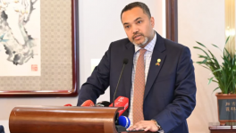
Planning Adviser Wahiduddin Mahmud shared the development while talking to journalists after the weekly meeting of the Executive Committee of the National Economic Council (Ecnec) in Dhaka today (17 September).
 Keep updated, follow The Business Standard's Google news channel

Land Adviser Ali Imam Majumder will lead the committee. Other members include Adviser Muhammad Fouzul Kabir Khan, who oversees road transport, railway, and power ministries, and Environment, Forest, and Climate Change Adviser Syeda Rizwana Hasan, and Housing and Public Works Adviser Adilur Rahman Khan.
The committee will work in conjunction with district administrations to collect the data and identify khas land, said Wahiduddin.

According to the planning adviser, a major obstacle to implementing development projects is the complex land acquisition process, which not only causes significant delays but also reduces the amount of agricultural land.

He clarified that the committee's work is expected to address this issue by prioritising the use of public land for new projects, which will ensure optimal use of government property and streamline project implementation.
The decision to form the committee was made during a meeting last Monday (15 September) to address the persistent issue of land acquisition delays and the shrinking of agricultural land due to urbanisation and infrastructure projects in sectors like education, health, and sports, said Wahiduddin.
That meeting highlighted that vast amounts of government-owned land remain unused, with some infrastructure projects, such as a "gene bank" facility, the land for which has been sitting idle for years.
By centralising the data on all unused public land, the government plans to prioritise its use for future projects, such as new universities, colleges, and other infrastructure, thereby avoiding the complexities and delays associated with acquiring new land for future development projects.